Nearest stops
Straight-line distance from the clinic entrance.
- Balzac utca trolleybus 73 110 m
- Csanády utca (Lehel tér M) trolleybus 76, bus 15 120 m
- Lehel tér M3 metro station (nearest entrance) metro M3 140 m
- Lehel tér M (tram) tram 12, tram 14 320 m
- Nyugati pályaudvar M3 metro station metro M3 400 m
- Nyugati Railway Station trains 470 m
- Nyugati pályaudvar M (tram) tram 4, tram 6 550 m
Step by step
- By metro: get off the M3 at Lehel tér. The clinic is on Váci út, about 150 metres from the nearest metro entrance, on the side opposite WestEnd.
- From Nyugati Railway Station: walk from Nyugati tér along Váci út towards Lehel tér; about 8 minutes.
- On the street, or in the Westend underground car park; with the Westend app parking costs 500 HUF per hour. From the car park, simply cross Váci út.
- The building is partly accessible: a few steps lead to the lift, and the lift works with a key card. If you need help getting up, call us in advance and a member of staff will come down for you. +36 30 790 6270
MozgásKlinika Újlipótváros
1132 Budapest, Váci út 28.
Loading the map lets Google set cookies. Until then no data is sent to Google.
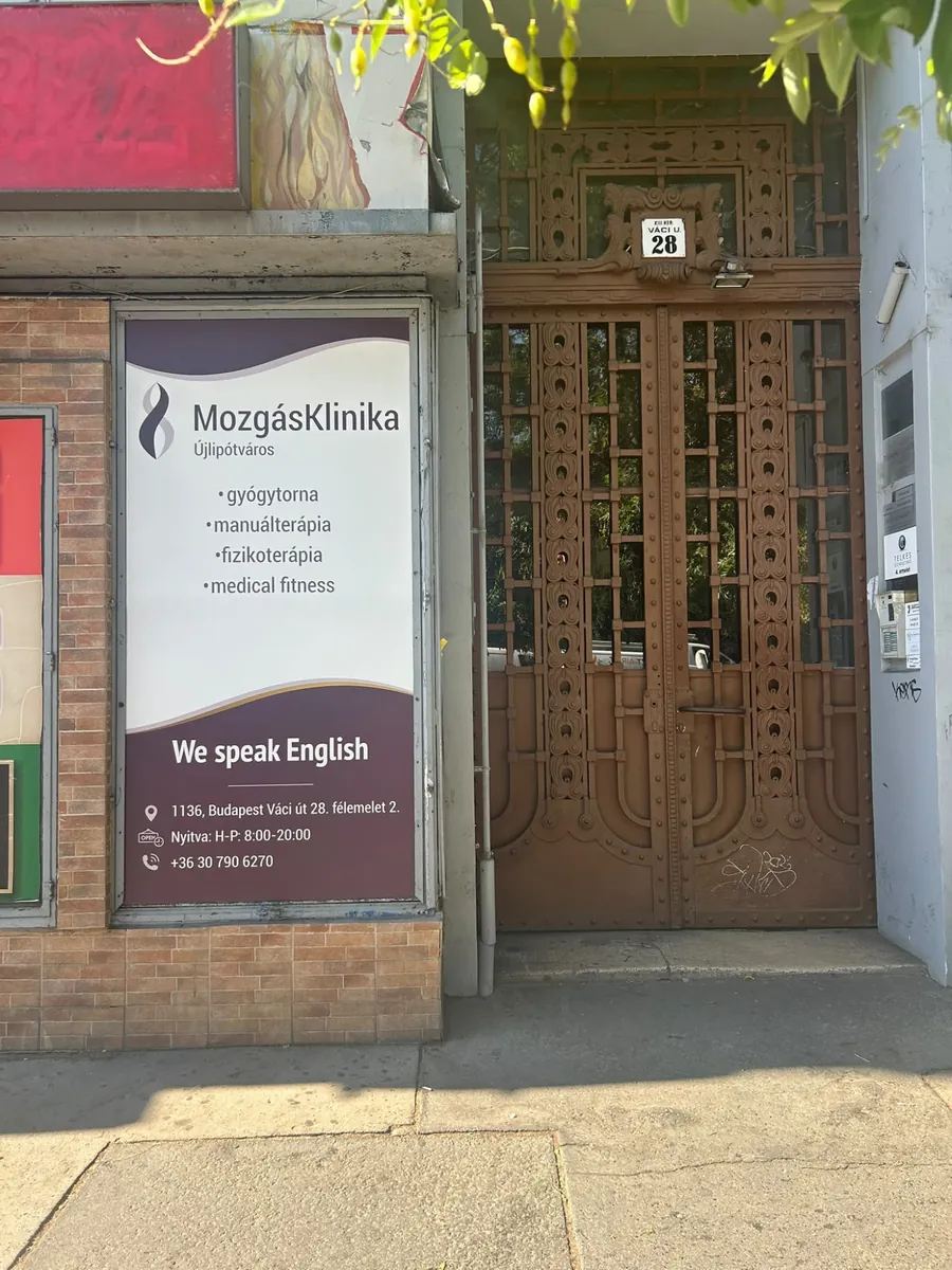
Finding our door
- The entrance is the street door of Váci út 28.: the ornate brown wrought-iron double door with the “XIII. ker. Váci u. 28” plate above it. Directly to its left you will see the MozgásKlinika Újlipótváros poster in the window.
- The door is kept locked: ring button 7 on the intercom on the right-hand side of the doorway.
- The clinic is on the mezzanine floor, door 2. The building is partly accessible: a few steps lead to the lift, and the lift works with a key card. If you need help getting up, call us in advance and a member of staff will come down for you.
- If you cannot get in or are running late, call us: +36 30 790 6270
Distances from landmarks and hubs
Walking route length and estimated time from OpenStreetMap. Use the Google Maps link for live directions.
Directions from your hotel
Budapest hotels, ordered by walking distance to the clinic. The Google Maps links give live directions on foot, by public transport and by car.
-
Crowne Plaza Budapest
Váci út 1–3., Budapest
- On foot
- about 4 min · 270 m
- By car
- walking is quicker
- Public transport
- Walking is easiest: about 4 min (270 m).
Walk: Crowne Plaza Budapest, Google Maps (opens in a new tab) Transit: Crowne Plaza Budapest, Google Maps (opens in a new tab) Drive: Crowne Plaza Budapest, Google Maps (opens in a new tab)
-
Adina Apartment Hotel Budapest
Hegedűs Gyula utca 52–54., Budapest
- On foot
- about 9 min · 700 m
- By car
- walking is quicker
- Public transport
- Walking is easiest: about 9 min (700 m).
Walk: Adina Apartment Hotel Budapest, Google Maps (opens in a new tab) Transit: Adina Apartment Hotel Budapest, Google Maps (opens in a new tab) Drive: Adina Apartment Hotel Budapest, Google Maps (opens in a new tab)
-
NH Budapest City
Vígszínház utca 3., Budapest
- On foot
- about 10 min · 780 m
- By car
- walking is quicker
- Public transport
- Walking is easiest: about 10 min (780 m).
Walk: NH Budapest City, Google Maps (opens in a new tab) Transit: NH Budapest City, Google Maps (opens in a new tab) Drive: NH Budapest City, Google Maps (opens in a new tab)
-
Marmara Hotel Budapest
Nagy Ignác utca 21., Budapest
- On foot
- about 10 min · 780 m
- By car
- walking is quicker
- Public transport
- Walking is easiest: about 10 min (780 m).
Walk: Marmara Hotel Budapest, Google Maps (opens in a new tab) Transit: Marmara Hotel Budapest, Google Maps (opens in a new tab) Drive: Marmara Hotel Budapest, Google Maps (opens in a new tab)
-
Radisson Blu Béke Hotel
Teréz körút 43., Budapest
- On foot
- about 13 min · 930 m
- By car
- walking is quicker
- Public transport
- Walking is easiest: about 13 min (930 m).
Walk: Radisson Blu Béke Hotel, Google Maps (opens in a new tab) Transit: Radisson Blu Béke Hotel, Google Maps (opens in a new tab) Drive: Radisson Blu Béke Hotel, Google Maps (opens in a new tab)
-
Hotel President
Hold utca 3–5., Budapest
- On foot
- about 20 min · 1.5 km
- By car
- 1.5 km · about 2 min without traffic
- Public transport
- M3 metro: Arany János utca station (110 m from the hotel), towards Újpest-központ, get off at Lehel tér; about 2 minutes on foot from there.
Walk: Hotel President, Google Maps (opens in a new tab) Transit: Hotel President, Google Maps (opens in a new tab) Drive: Hotel President, Google Maps (opens in a new tab)
-
Danubius Hotel Hélia
Kárpát utca 62–64., Budapest
- On foot
- about 22 min · 1.6 km
- By car
- 1.8 km · about 3 min without traffic
- Public transport
- M3 metro: Dózsa György út station (580 m from the hotel), towards Kőbánya-Kispest, get off at Lehel tér; about 2 minutes on foot from there.
Walk: Danubius Hotel Hélia, Google Maps (opens in a new tab) Transit: Danubius Hotel Hélia, Google Maps (opens in a new tab) Drive: Danubius Hotel Hélia, Google Maps (opens in a new tab)
-
Hotel Moments Budapest
Andrássy út 8., Budapest
- On foot
- about 23 min · 1.7 km
- By car
- 2.2 km · about 4 min without traffic
- Public transport
- M3 metro: Arany János utca station (320 m from the hotel), towards Újpest-központ, get off at Lehel tér; about 2 minutes on foot from there.
Walk: Hotel Moments Budapest, Google Maps (opens in a new tab) Transit: Hotel Moments Budapest, Google Maps (opens in a new tab) Drive: Hotel Moments Budapest, Google Maps (opens in a new tab)
-
Corinthia Hotel Budapest
Erzsébet körút 43–49., Budapest
- On foot
- about 23 min · 1.8 km
- By car
- 1.7 km · about 3 min without traffic
- Public transport
- Tram 4 or 6: Király utca / Erzsébet körút stop (100 m from the hotel) to Nyugati pályaudvar M; about 8 minutes on foot along Váci út from there.
Walk: Corinthia Hotel Budapest, Google Maps (opens in a new tab) Transit: Corinthia Hotel Budapest, Google Maps (opens in a new tab) Drive: Corinthia Hotel Budapest, Google Maps (opens in a new tab)
-
Aria Hotel Budapest
Hercegprímás utca 5., Budapest
- On foot
- about 25 min · 1.9 km
- By car
- 2.3 km · about 5 min without traffic
- Public transport
- M3 metro: Deák Ferenc tér station (240 m from the hotel), towards Újpest-központ, get off at Lehel tér; about 2 minutes on foot from there.
Walk: Aria Hotel Budapest, Google Maps (opens in a new tab) Transit: Aria Hotel Budapest, Google Maps (opens in a new tab) Drive: Aria Hotel Budapest, Google Maps (opens in a new tab)
-
Prestige Hotel Budapest
Vigyázó Ferenc utca 5., Budapest
- On foot
- about 28 min · 2.1 km
- By car
- 2.4 km · about 5 min without traffic
- Public transport
- M3 metro: Arany János utca station (540 m from the hotel), towards Újpest-központ, get off at Lehel tér; about 2 minutes on foot from there.
Walk: Prestige Hotel Budapest, Google Maps (opens in a new tab) Transit: Prestige Hotel Budapest, Google Maps (opens in a new tab) Drive: Prestige Hotel Budapest, Google Maps (opens in a new tab)
-
Al Habtoor Palace Budapest
Erzsébet tér 9–10., Budapest
- On foot
- about 29 min · 2.2 km
- By car
- 2.3 km · about 4 min without traffic
- Public transport
- M3 metro: Deák Ferenc tér station (80 m from the hotel), towards Újpest-központ, get off at Lehel tér; about 2 minutes on foot from there.
Walk: Al Habtoor Palace Budapest, Google Maps (opens in a new tab) Transit: Al Habtoor Palace Budapest, Google Maps (opens in a new tab) Drive: Al Habtoor Palace Budapest, Google Maps (opens in a new tab)
-
Kimpton BEM Budapest
Bem József tér 3., Budapest
- On foot
- about 30 min · 2.3 km
- By car
- 2.4 km · about 4 min without traffic
- Public transport
- Tram 4 or 6: Margit híd, budai hídfő H stop (280 m from the hotel) to Nyugati pályaudvar M; about 8 minutes on foot along Váci út from there.
Walk: Kimpton BEM Budapest, Google Maps (opens in a new tab) Transit: Kimpton BEM Budapest, Google Maps (opens in a new tab) Drive: Kimpton BEM Budapest, Google Maps (opens in a new tab)
-
Kempinski Hotel Corvinus Budapest
Erzsébet tér 7–8., Budapest
- On foot
- about 30 min · 2.3 km
- By car
- 2.3 km · about 4 min without traffic
- Public transport
- M3 metro: Deák Ferenc tér station (170 m from the hotel), towards Újpest-központ, get off at Lehel tér; about 2 minutes on foot from there.
Walk: Kempinski Hotel Corvinus Budapest, Google Maps (opens in a new tab) Transit: Kempinski Hotel Corvinus Budapest, Google Maps (opens in a new tab) Drive: Kempinski Hotel Corvinus Budapest, Google Maps (opens in a new tab)
-
Four Seasons Hotel Gresham Palace
Széchenyi István tér 5–6., Budapest
- On foot
- about 30 min · 2.3 km
- By car
- 2.7 km · about 5 min without traffic
- Public transport
- M3 metro: Deák Ferenc tér station (510 m from the hotel), towards Újpest-központ, get off at Lehel tér; about 2 minutes on foot from there.
Walk: Four Seasons Hotel Gresham Palace, Google Maps (opens in a new tab) Transit: Four Seasons Hotel Gresham Palace, Google Maps (opens in a new tab) Drive: Four Seasons Hotel Gresham Palace, Google Maps (opens in a new tab)
-
Anantara New York Palace Budapest
Erzsébet körút 9–11., Budapest
- On foot
- about 31 min · 2.3 km
- By car
- 2.7 km · about 5 min without traffic
- Public transport
- Tram 4 or 6: Blaha Lujza tér M stop (210 m from the hotel) to Nyugati pályaudvar M; about 8 minutes on foot along Váci út from there.
Walk: Anantara New York Palace Budapest, Google Maps (opens in a new tab) Transit: Anantara New York Palace Budapest, Google Maps (opens in a new tab) Drive: Anantara New York Palace Budapest, Google Maps (opens in a new tab)
-
InterContinental Budapest
Apáczai Csere János utca 12–14., Budapest
- On foot
- about 34 min · 2.6 km
- By car
- 2.5 km · about 4 min without traffic
- Public transport
- M3 metro: Deák Ferenc tér station (470 m from the hotel), towards Újpest-központ, get off at Lehel tér; about 2 minutes on foot from there.
Walk: InterContinental Budapest, Google Maps (opens in a new tab) Transit: InterContinental Budapest, Google Maps (opens in a new tab) Drive: InterContinental Budapest, Google Maps (opens in a new tab)
-
Mercure Budapest City Center
Váci utca 20., Budapest
- On foot
- about 35 min · 2.6 km
- By car
- 3.7 km · about 7 min without traffic
- Public transport
- M3 metro: Ferenciek tere station (390 m from the hotel), towards Újpest-központ, get off at Lehel tér; about 2 minutes on foot from there.
Walk: Mercure Budapest City Center, Google Maps (opens in a new tab) Transit: Mercure Budapest City Center, Google Maps (opens in a new tab) Drive: Mercure Budapest City Center, Google Maps (opens in a new tab)
-
Novotel Budapest Danube
Bem rakpart 33–34., Budapest
- On foot
- about 36 min · 2.7 km
- By car
- 2.7 km · about 5 min without traffic
- Public transport
- By public transport: Google Maps shows the current route (link below).
Walk: Novotel Budapest Danube, Google Maps (opens in a new tab) Transit: Novotel Budapest Danube, Google Maps (opens in a new tab) Drive: Novotel Budapest Danube, Google Maps (opens in a new tab)
-
Budapest Marriott Hotel
Apáczai Csere János utca 4., Budapest
- On foot
- about 38 min · 2.8 km
- By car
- 3.5 km · about 7 min without traffic
- Public transport
- M3 metro: Deák Ferenc tér station (470 m from the hotel), towards Újpest-központ, get off at Lehel tér; about 2 minutes on foot from there.
Walk: Budapest Marriott Hotel, Google Maps (opens in a new tab) Transit: Budapest Marriott Hotel, Google Maps (opens in a new tab) Drive: Budapest Marriott Hotel, Google Maps (opens in a new tab)
-
Matild Palace
Váci utca 36., Budapest
- On foot
- about 38 min · 2.9 km
- By car
- 3.5 km · about 7 min without traffic
- Public transport
- M3 metro: Ferenciek tere station (210 m from the hotel), towards Újpest-központ, get off at Lehel tér; about 2 minutes on foot from there.
Walk: Matild Palace, Google Maps (opens in a new tab) Transit: Matild Palace, Google Maps (opens in a new tab) Drive: Matild Palace, Google Maps (opens in a new tab)
-
Hilton Budapest
Hess András tér 1–3., Budapest
- On foot
- about 48 min · 3.6 km
- By car
- 4.3 km · about 8 min without traffic
- Public transport
- By public transport: Google Maps shows the current route (link below).
Walk: Hilton Budapest, Google Maps (opens in a new tab) Transit: Hilton Budapest, Google Maps (opens in a new tab) Drive: Hilton Budapest, Google Maps (opens in a new tab)
-
Danubius Grand Hotel Margitsziget
Margitsziget, Budapest
- On foot
- about 49 min · 3.6 km
- By car
- 3.8 km · about 7 min without traffic
- Public transport
- By public transport: Google Maps shows the current route (link below).
Walk: Danubius Grand Hotel Margitsziget, Google Maps (opens in a new tab) Transit: Danubius Grand Hotel Margitsziget, Google Maps (opens in a new tab) Drive: Danubius Grand Hotel Margitsziget, Google Maps (opens in a new tab)
-
Park Inn by Radisson Budapest
Szekszárdi utca 16–18., Budapest
- On foot
- about 64 min · 4.8 km
- By car
- 5.1 km · about 8 min without traffic
- Public transport
- M3 metro: Újpest-városkapu station (640 m from the hotel), towards Kőbánya-Kispest, get off at Lehel tér; about 2 minutes on foot from there.
Walk: Park Inn by Radisson Budapest, Google Maps (opens in a new tab) Transit: Park Inn by Radisson Budapest, Google Maps (opens in a new tab) Drive: Park Inn by Radisson Budapest, Google Maps (opens in a new tab)
Data source: OpenStreetMap (stops and routes, September 2026). Walking times are estimates and driving times assume no traffic; the Google Maps links show exact, current routes. The hotel list is for orientation only and does not imply any partnership.
Questions about getting here
Which metro station is closest to the clinic?
The closest metro station to MozgásKlinika Újlipótváros is Lehel tér on the M3 line: its nearest entrance is about 150 metres from Váci út 28. Nyugati pályaudvar station, also on the M3, is about 400 metres away.
How far is the clinic from Nyugati Railway Station?
From Nyugati Railway Station, MozgásKlinika Újlipótváros is about a 8-minute walk (580 m) along Váci út towards Lehel tér. Trams 4 and 6 and the M3 metro also stop at Nyugati tér.
Where is the clinic in relation to WestEnd?
MozgásKlinika Újlipótváros is on Váci út, directly opposite the WestEnd shopping centre: about 3 minutes on foot (240 m); you simply cross Váci út. You can also park in the WestEnd underground car park.
Which buses, trolleybuses and trams stop nearby?
Near MozgásKlinika Újlipótváros stop trolleybus 73 (Balzac utca, about 110 m), trolleybus 76 and bus 15 (Csanády utca, about 120 m), trams 12 and 14 (Lehel tér, about 320 m) and trams 4 and 6 (Nyugati pályaudvar, about 550 m).
Where can I park?
At MozgásKlinika Újlipótváros you can park on the street or in the WestEnd underground car park; with the WestEnd app, parking costs 500 HUF per hour. From the car park you simply cross Váci út.
Is the clinic accessible?
The building is partly accessible: a few steps lead to the lift, and the lift works with a key card. If you need help getting up, call us in advance and a member of staff will come down for you.
How far are Margaret Island and Margaret Bridge?
From MozgásKlinika Újlipótváros, Margaret Bridge is about 17 minutes on foot (1.2 km), and the Musical Fountain on Margaret Island about 27 minutes (2.0 km). Lehel Market Hall is about 7 minutes away.